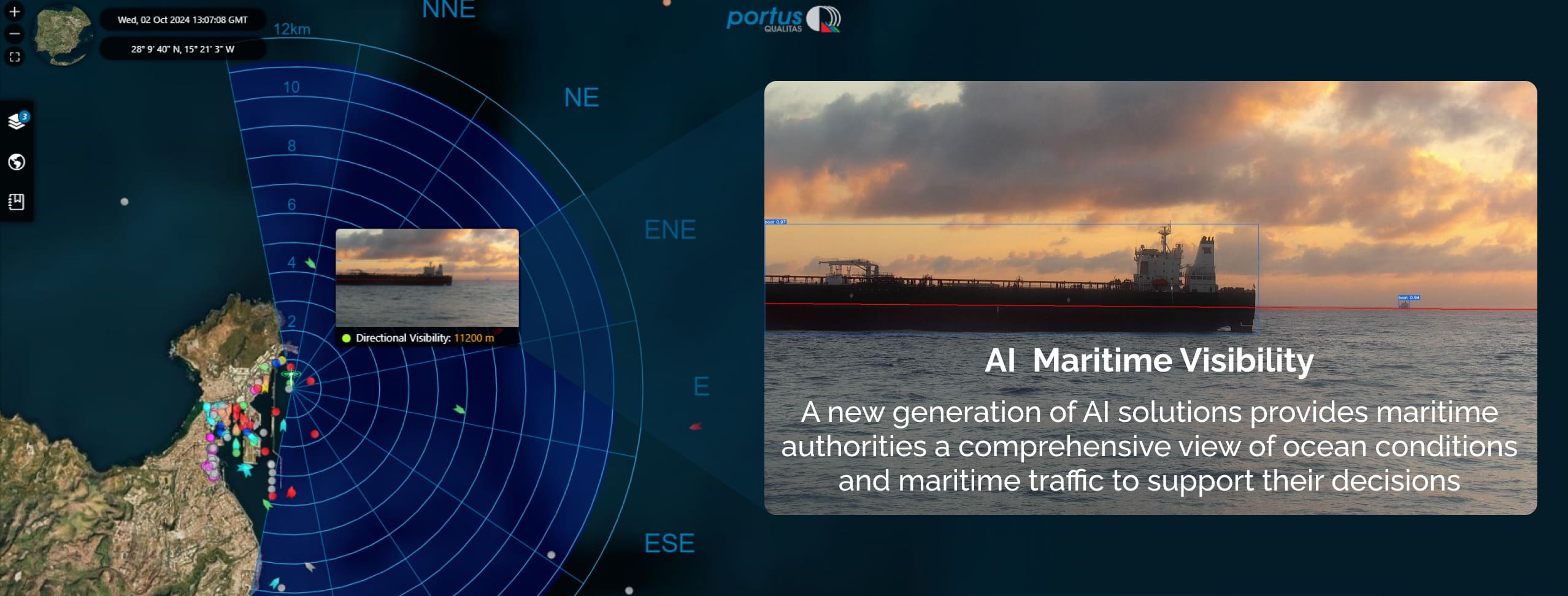
AI MARITIME VISIBILITY solution, an advanced AI (artificial intelligence) system that improves safety and efficiency in port and maritime environments through the precise measurement of directional atmospheric visibility. This pioneering product combines artificial intelligence technologies, an optical sensor and an AIS (Automatic Identification System) receiver to offer port authorities and maritime traffic managers an essential tool for managing port approach operations and remote-controlled navigation.
Atmospheric Visibility : A Challenge or Key to Safe Navigation
Directional atmospheric visibility is a critical factor in port environments, as it directly affects the safety of daily maneuvers and operations. Factors such as fog, rain and dust can drastically reduce the ability of vessels to navigate safely, increasing the risk of collisions, grounding and other maritime accidents .
In the conference given by the Head of the VTS Area of the Jovellanos Center of SASEMAR, Mr. Carlos Fernández Salinas, on October 22, 2020, under the title » Autonomous vessels and accident prevention», he presented visibility as the definitive variable for autonomous navigation of the future, explaining how » visibility conditions govern the behavior of vessels based on navigation rules 4 to 19 «. Knowing in a quantitative and directional way how this variable evolves in real time will make it possible to define speed , heading, separation , etc. for all types of maneuvers, in particular for the entry and exit of vessels in the port.
With AI MARITIME VISIBILITY product we present a solution that responds to this need, providing accurate data and clear images of environmental conditions every ten minutes. Our solution measures, in addition to the prevailing visibility, directional visibility in angular sectors of 22.5 degrees in the form of a visibility rose similar to how waves or winds are represented in the maritime sector.
Technology and Reliability at the Service of Ports and Navigation Management
AI MARITIME VISIBILITY system uses a PTZ (Pan, Tilt, Zoom) camera, an AIS receiver and a set of advanced artificial intelligence algorithms to automatically detect atmospheric conditions and the position of vessels. These algorithms allow the ocean /atmosphere interface to be analyzed, extracting visual information, providing a comprehensive analysis of the situation in the maritime environment .
Unlike conventional systems, our technology fuses multiple data sources, ensuring a detailed representation of the port environment. Vessels of a certain size have AIS transmitters, but not all have this technology. For this reason, we have integrated Deep Learning capabilities into the system, allowing us to detect and track vessels not registered in the AIS system, thus completing the visual information with a robust analysis of patterns and optical detection of objects from images, which allows us to define a layer of optical detections complementary to the information provided by the AIS system.
Innovation and Added Value for the Future of Ports
With AI MARITIME VISIBILITY , we have created a first-of-its-kind solution that not only addresses the current challenges of atmospheric visibility in ports, but also lays the foundation for a safer and more efficient port infrastructure ready to receive autonomous navigation in the future. Our system has been designed to optimize both safety in port operations and maritime traffic management, improving the operational capacity of ports and reducing the risks associated with lack of visibility.
QAISC is committed to developing technologies that make a difference. With the implementation of AI MARITIME VISIBILITY, we not only offer our clients a tool to improve security, but also a strategic solution to optimize their infrastructures, increasing operational capacity and maximizing their logistical efficiency.

QUALITAS ARTIFICIAL INTELLIGENCE & SCIENCE


Copyright © 2024. Qualitas Artificial Intelligence & Science . All rights reserved.